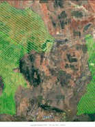
Aerial Survey Completed
Project Update
Publish date: April 11, 2025

Part of the project
Monitoring Multi-Dimensional Impacts of Payment for Ecosystem Service Projects
Monitoring Multi-Dimensional Impacts of Payment for Ecosystem Service ProjectsAerial Survey Completed
Project Update
Part of the project
Monitoring Multi-Dimensional Impacts of Payment for Ecosystem Service Projects
Monitoring Multi-Dimensional Impacts of Payment for Ecosystem Service ProjectsPublish date: April 11, 2025
The aerial survey for the ID PES project area has been successfully completed. In the beginning of the year, the Kenyan company Ramani captured photographs using a Vexcel UltracCam X large format camera system mounted on an aircraft. This aerial imagery, combined with complementary geospatial data, form the foundation for the newly proposed photogrammetric monitoring approach: Through a series of processing steps, the data will later be transformed into highly detailed 3D models and maps with a resolution of 20-25 cm, representing the project terrain, including vegetation and buildings. With the completion of the aerial survey, the digital backbone for the monitoring strategy is now in place.
Data for areas marked with yellow hatching will be recollected in the summer of 2025 due to cloud contamination.
Team
- Project contact
Project contact
Dr. Dominique Schmid
Postdoctoral Researcher
